Pisang Peak Climbing

Duration: 19 Days / 18 Nights
  • Destination: Nepal
  • Trip Difficulty: Strenuous
  • Style: Peak Climbing
  • Transportation: Tourist Bus, Car & Airplane
  • Meals: BLD (Breakfast, Lunch & Dinner)
  • Accommodation: Hotel, Lodge &Tent
  • Group Size: 1-18
  • Max Altitude: 6,091m/19,984ft

Highlights of Pisang Peak Climbing

  • Thakali and Manangese ethnic villages of Manang Valley
  • Breathtaking view of Annapurna (8,091m) and Dhaulagiri (8,167m) Massifs
  • Flora and fauna of Annapurna Conservation Area
  • Crossing Thorung La Pass (5,416m)
  • The popular pilgrimage site Muktinath Temple
  • Apple orchards of Mustang
  • Scenic flight to Pokhara from Jomsom
  • Exploration of Pokhara city

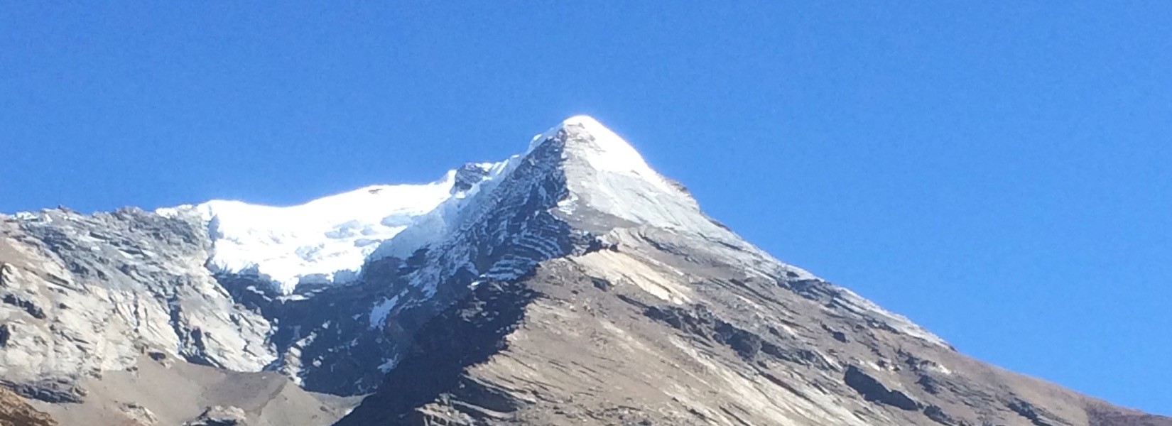
Climbing Pisang Peak (6,091 m) is a moderately difficult mountaineering challenge. Pisang Peak lies between Annapurna (8,091m) and Manalsu (8,163m) region. This program is combined with a part of the renowned Annapurna Circuit trek. Therefore, it is gaining a popularity among aspiring mountaineers. Pisang Peak does not demand high resilience or good mountaineering skills. If you are one with a desire to climb trekking peaks of Nepal, that alone would suffice in the first place.

The Thakali, Manangese and mixed community villages are also the striking features to make this adventurous journey in Nepal more vibrant. The Tibetan Monasteries, Mountaineering School of Manang add to the beauty of this trekking and climbing package. The Typical Thakali cuisine (daal bhaat and fermented green vegetables pickle) is something you shouldn’t miss while visiting Manang Valley.

The variation of geography ranging from sub-tropical to desert-like region of Manang Valley is another thrilling aspect of this trip. You can witness the paddy, wheat, barley and potato fields to barren landscapes while ascending and descending towards the destination. The dense forests of rhododendron, oak and pine trees are really beautiful feature to experience once in lifetime. The variety of animal and bird species inhabiting in the Annapurna Conservation Area (ACA) contribute to give you lifelong memory.

Our route is through the the Annapurna Circuit from Beshishahar to the village of Pisang. From here, the base camp can be reached on a single day, at an altitude of about 4,380 meters. The base camp for Pisang Peak is laid out in a pasture. From here, we move up to the High Camp (5,400 m) at a saddle in South-western ridge. The final ascent, consisting of steep inclinations of ice and snow up to the summit is done by following the same ridge.

Although this part is challenging, ascent up Pisang peak is relatively undemanding. From the top of the peak, you can enjoy astounding views of peaks of the Annapurna (8,091m) Range. Annapurna II, Annapurna IV, Gangapurna and Glacier Dome – all are visible from one single spot of joy. Later in the day, you descend to the base camp and begin the journey onwards.

On your way back, you can trek in the beautiful valley of Manang over the world’s highest pass, Thorang-La (5,416 m). From there, descend to Muktinath and then to Jomsom from where you can catch a flight to Pokhara. Muktinath Temple is one of the major shrines of Nepal equally respected by Hindus and Buddhists. The ever-burning flame with the natural gas and the 108 waterspouts are the main attractions of this shrine. Every year, hundreds of thousand pilgrims from India and Nepal visit this sacred place in different season.

FAQs:

1. Where is Pisang Peak?

Pisang Peak (6,091m) is one of the trekking peaks of Nepal located in Annapurna region between Annapurna region and Manaslu (8.163m) region. It is one of the frequently climbed peak in the Manang Valley. It requires around 7/8 days to complete Pisang Peak climbing from Pokhara.

2. How difficult is Pisang Peak climbing?

It is moderately challenging to climb Pisang Peak. The trail from High Camp to Pisang Peak Summit is challenging due to some crevasses. However, if you are determined and with little knowledge about using climbing gears, you can easily do it away. Moreover, the Sherpa guide who leads your team gives you all the skills and techniques to win over this trekking peak. Acclimatization also plays a great role to accomplish this task. Follow the instructions of the climbing guide by taking enough rest to beat this climbing in Nepal. Besides, don’t forget to have enough drinking water and hygienic food items to remain physically fit.

3. Can I customize Pisang Peak climbing package?

Yes, you can definitely customize this package. You can cut short the package by choosing Pisang Peak climbing and return to Pokhara or Kathmandu right from Manang. Or you can extend the itinerary by choosing to Thorung La Muktinath Mustang trek. The second option gives you a lifelong memory of crossing one of the highest altitude Himalayan passes in the world.

4. How can I book Pisang Peak climbing package?

Nowadays, the information about Pisang Peak climbing details about itinerary, cost and difficulty are uploaded on the Internet. You can search it on the web and book it through the local tour and trekking operator located in Kathmandu. Among the local agencies, Orbit Alpine Adventure is the one run by the Nepalese who has done peak climbing in Everest, Langtang and Annapurna including Pisang Peak climbing many times. To get help from us, click www.orbitalpineadventure.com.

5. What is the best time for Pisang Peak climbing?

The best time for Pisang Peak climbing is from mid March to mid May and from mid September to mid December. In this time, it is easy to climb the peak as there is less snow deposit on the trail. Next, you can have a 360-degree panoramic view of snowcapped peaks and wonderful landscapes from the top of Pisang Peak.

6. Do I need climbing gears to climb Pisang Peak?

Yes, you do. Although climbing Pisang Peak is not much difficult, you need to be fully prepared for this mission. You need to bring climbing gears and should have knowledge about using them properly. The peak climbing gears are like this:

Fixed Rope

Climbing Rope

Tent

Crampons

Altimeter Watch       

Ice Axe

Sleeping Bag

Waterproof Trousers

Gas Stove         

Gas Fuel       

Ascender (Jumar)

Mattress

Figure 8/ Descender           

Carabiner

Tape Slings

Harness

Helmets  

Ice Screw      

Belay Gloves       

Ski Goggles      

Headlamps

Trekking Poles/ Ski Poles    

Snow Shovel            

Large Thermos      

Water Bottle           

Mountaineering Jackets        

Cooking Pots and Equipment      

Mountaineering/ Climbing Boots

Climbing Backpacks           


Day to Day Itinerary

OPEN ALL DAYS Outline Itinerary

On your arrival at Tribhuvan International Airport, you will be met by our staff, who will then take you to your hotel and served welcome drinks. In the afternoon, you can take a stroll around and visit shops, restaurants and bars. Stay overnight at the hotel.

  • Meals: Wellcome Dinner
  • Accommodation: Three Star hotel
  • Place: Kathmandu
  • Altitude: 1,350m/4,429ft

Checking your climbing equipment’s, and discussing the climb with the climbing/trekking guide. Stay overnight at hotel in Kathmandu.

  • Meals: Breakfast
  • Accommodation: Three Star Hotel
  • Place: Kathmandu
  • Altitude: 1,350m/4,429ft

After early-morning breakfast, our guide will pick you up from the hotel and take you to the bus station. Drive from Kathmandu to Bhulbhule via Besisahar, takes about eight hours. Stay overnight at lodge in Bhulbhule.

  • Meals: Breakfast, Lunch, Dinner
  • Accommodation: Teahouse
  • Place: Bhulbhule
  • Altitude: 823m/2,700ft
  • Time: 8 Hours

Trek from Bhulbhule to Chamje (1,410m.) takes about seven hours. Ahead the Marshyangdi valley forms a steep V-shape and you follow the winding mountain path down through Syange (1,100m.) where there is a beautiful waterfall above it and along the river for some distance. The trail then climbs steeply and the path is cut into the sheer cliff-face some 200-300m above the riverbed.. Now the trail begins to observe small ups and downs to Chamje through the forests. Stay overnight at lodge.

  • Meals: Breakfast, Lunch, Doinner
  • Accommodation: Teahouse
  • Place: Chamje
  • Altitude: 1,410m/4,626ft
  • Time: 7 Hours

Trek from Chamje (1,410m.) to Dharapani (1,960m.) takes about six hours. The first part of the trail descends to the river and after crossing a suspension bridge, you begin a climb to Sattale (1,550m.) on a path so steep that it seems one slip would send you hurtling down into the valley. You continue on an undulating path above the river. Climbing the zigzag path to the top of the hill, we see the level, plain of Tal (1,700m.) before us. You descend to a grassy riverbank that leads to Tal with its hotels and teahouses. Here you can enjoy the exhilarating waterfalls .Beyond Tal, the valley narrows and the path becomes high and winding and in several areas hewn from the rock itself. Beyond the small village of Karte (1,900m.), there is a bit more cliff-walking before the path drops again to the river. You cross a suspension bridge and climb the short distance to the stone Mani marking the entrance to Dharapani (1,960m.), and our camp for the night. Stay overnight at lodge.

  • Meals: Breakfast, Lunch, Dinner
  • Accommodation: Teahouse
  • Place: Dharapani
  • Altitude: 1,960m/6,430ft
  • Time: 6 Hours

Trek from Dharapani to Chame (2,675m.) takes about five and half hours. As you cut through a narrow field from the village, the Dudh Khola, originates from the south face of Manaslu, enters on the opposite bank. The Marshyangdi then veers to the left and as Annapurna II becomes visible ahead, you arrive at Bagarchhap, a Bhote village with prayer flags fluttering in the breeze around Buddhist monastery. Continuing to climb through forests of pine and oak, you pass through Danaque (2,210m.). The trail goes through flat level until you reach Chame where there are government offices, shops and hotels. Chame is the administrative headquarters for the Manang district. Stay overnight at lodge.

  • Meals: Breakfast, Lunch, Dinner
  • Accommodation: Teahouse
  • Place: Chame
  • Altitude: 2,675m/8,776ft
  • Time: 6 Hours

With Lamjung Himal (6,893m) sparkling in the morning sun, you set off for Pisang. Trek from Chame to Pisang (3,100m.) takes about five hours. With Lamjung Himal (6,893m) sparkling in the morning sun, you set off for Pisang. The mountain disappears as you climb the path up the valley, passing a huge apple orchard. You continue through a fir and pine forest, climbing to a high, rocky area as the opposite bank becomes an impassable cliff. From this point the valley becomes extremely steep-sided as you follow the path to Bhratang (2,950m.). You now walk through a pine forest and as the forest ends, the valley changes from a V-shape to a gentle U-shape, opening up a wonderful vista before us. You can see the east peak of Annapurna II as well as Pisang Peak (6,091m.) to the northeast. Continuing on, you come to a long Mani wall by a bridge and the lower village of Pisang. Stay overnight at lodge.

  • Meals: Breakfast, Lunch, Dinner
  • Accommodation: Teahouse
  • Place: Pisang
  • Altitude: 3,100m/10,171ft
  • Time: 5 Hours

Trek from Pisang to Pisang Base Camp takes about six hours. The trail is steep ascent passing through Upper Pisang. En route, you cross forests of pine and local vegetation. The views of Annapurna rang welcome you. Stay overnight in camp.

  • Meals: Breakfast, Lunch, Dinner
  • Accommodation: Camp
  • Place: Pisang Base Cam
  • Altitude: 4,380m/14,370f
  • Time: 6 Hours.

Trek from Pisang Base Camp to Pisang High Camp takes about four hours. You trek along rocky glacier path to High Camp. You will be completely charmed by the panoramic views of Annapurna range, Chulu East, Chulu Far East, Nawal peak, Tilicho Peak and many other unnamed mountains and peaks. Stay overnight in camp.

  • Meals: Breakfast, Lunch, Dinner
  • Accommodation: Camp
  • Place: Pisang High Camp
  • Altitude: 5,400m/17,717ft
  • Time: 4 Hours

Summit to Pisang peak and back to Pisang Base Camp takes about ten hours. At the summit of Pisang peak, you can have closer panoramic views of Annapurna range, Chulu East, Chulu Far East, Nawal peak, Tilicho peak, Manaslu, Ganesh Himal, Tibetan mountains, Kang Guru Peak, Gyaji Kang peak, Tilje peak, Kuchubhro peak and many more. Stay overnight in camp.

  • Meals: Breakdast, Dry Food, Dinner
  • Accommodation: Camp
  • Place: Pisang Base Cam
  • Altitude: 6,091m/19,984ft
  • Time: 10 Hours

Trek from Pisang Base Camp to Pisang takes about four hours. The trail moves steeply down all the way to Pisang. The view of Annapurna range accompanies you. Stay overnight at lodge.

  • Meals: Breakfast, Lunch, Dinner
  • Accommodation: Teahouse
  • Place: Pisang
  • Altitude: 3,100m/10,171ft
  • Time: 4 Hours

Trek from Pisang to Manang (3,440m.) takes about five and a half hours. Beyond Pisang, the trail climbs a steep ridge affords good views of the Manang valley and Tilicho peak (7,145m.). Just beyond this point you cross the considerably reduced flow of the Marshyangdi Khola via a wooden bridge to the tiny village of Mungji. Cultivated fields appear on both sides of the path and off to the right, below a craggy mountain, you can see the village of Bryaga with its splendid monastery. Large Chortens and Mani walls abound and the tall peaks of the Himalaya spread out before us – Annapurna II, Annapurna III, Annapurna IV, Gangapurna [7,455m] and, to the rear, Tilicho Peak [7,145m]. Stay overnight at lodge.

  • Meals: Breakfast, Lunch, Dinner
  • Accommodation: Teahouse
  • Place: Manang
  • Altitude: 3,440m/11,286ft
  • Time: 6 Hours

Trek from Manang to Yak Kharka (4,350m.) takes about three and half hours. Now the trail ascends gently all the way to Yak Kharka passing through the Gunsang (3,960m.) village. En route, you can see panoramic views all the day. Stay overnight at lodge.

  • Meals: Breakfast, Lunch, Dinner
  • Accommodation: Teahouse
  • Place: Yak Kharka
  • Altitude: 4,350m/14,272ft
  • Time: 4 Hours

Trek from Yak Kharka to Thorong Phedi (4,420m.) takes about 3 and half hours. Leaving Yak Kharka, you climb gradually to a ridge before descending to the headwaters of the Marshyangdi and crossing via a covered wooden bridge. After a short ascent up the mountain path on the right bank, you follow a narrow trail across an unstable spree slope and then descend to Thorung Phedi. Stay overnight at lodge.

  • Meals: Breakfast, Lunch, Dinner
  • Accommodation: Teahouse
  • Place: Thorong Phedi
  • Altitude: 4,420m/14,501ft
  • Time: 4 Hours

Trek from Thorong Phedi to Muktinath (3,850m.) via Thorong La (5,416m.) Pass and it takes about seven hours. You start early today for your crossing of Thorung La [5416m]. The trail becomes steep immediately on leaving camp but as this trail has been used by local people for hundreds of years the path is well defined. The gradient then eases and after around 4 hours of steady climbing you reaches the chorten and prayer flags of the pass. The views are dramatic to say the least, from the snow-covered mountains above, to the head of the Kali Gandaki valley below and the brown and purple hills of Mustang which are spread out before us. The descent to Muktinath is a knee pounding 1,600m but it’s compensated for with excellent views of Dhaulagiri. Eventually the moraines give way to grassy slopes before a pleasant walk along the Jhong Khola Valley to Muktinath and its shrines and temple. Stay overnight at lodge.

  • Meals: Breakfast, Lunch, Dinner
  • Accommodation: Teahouse
  • Place: Muktinath
  • Altitude: 3,850m/12,631f
  • Time: 7 Hours

After breakfast, you begin the journey following the trail that goes past some fine apple gardens of the Mustang Valley. Moving further, you walk past some Mustangese villages reflecting Tibetan Buddhist culture and tradition. Then, you walk past Kagbeni, the gateway to Upper Mustang trek to enter into the Kali Gandaki Valley. Enjoying the alluring view of the snowy peaks of Annapurna and Dhaulagiri Himalayan Ranges, you reach Jomsom.

Jomsom is the administrative headquarters of Mustang district that has an airport connecting the lake city Pokhara. Here, you can visit an Ecological Museum to know more about the rich culture, flora and fauna of Mustang region. 

  • Meals: Breakfast, Lunch, Dinner
  • Accommodation: Teahouse
  • Place: Jomsom
  • Altitude: 2,715m/8,908ft
  • Time: 6 Hours

Fly from Jomsom to Pokhara takes about 35 minutes. The flights are available during the morning time. The strong breeze blows during and after and frequent change of the weather prevents the flight being landed and taken off in the afternoon. Alternatively, you can drive to Pokhara via Beni, which is the gateway to Guerrilla trek or Dolpo region trek. But, flying is better than driving along the hilly roadway.

After the plane lands at Pokhara Airport, you will be transferred to the hotel. In the remaining time, you can go for an excursion around the main places of Pokhara. You can experience some adventurous sports like zip flying, boating on the Phewa Lake, hot air ballooning and paragliding in Pokhara as well. While in Pokhara, don’t miss out to join the night celebration at the Lake Side. Stay overnight at hotel in Pokhara.

  • Meals: Breakfast, Lunch, Dinner
  • Accommodation: Three Star Hotel
  • Place: Pokhara
  • Altitude: 950m/3,117ft
  • Time: 25 Minutes

Drive from Pokhara to Kathmandu takes about seven hours. While driving from Pokhara to Kathmandu, you head up to Damauli, Dumre, Muglin and Kurintar where Nepal’s first Cable car is operated to reach to Manakamana Temple. From Naubishe you climb up to Thankot, the gateway to capital city of Kathmandu

  • Meals: Breakfast, Farewell Diner
  • Accommodation: Three Star Hotel
  • Place: Kathmand
  • Altitude: 1,350m/4,429ft
  • Time: 7 Hours

As per your flight schedule, we will transfer you from your hotel to the Airport for your flight back home.

  • Meals: Breakfast

Useful Info

For price quotation and service details please contact us.